


Jaunpur district has a climate consistent with that of the Northern Plain and Central Highlands including the Aravalli range, hot semi-arid eco-region 4.3 and hot dry ecoregion 9.2. The temperature varies between about 4 °C (39 °F) and 44 °C (111 °F).The annual normal rainfall is 1,098 millimetres (43.2 in). The monsoon season occurs from the third week of June to the first week of October. Normally, there are 46 rain days per year of which 31 occur in the monsoon season. The district regularly suffers drought and pestilence.
The main field crops of Jaunpur district are: rice, maize, pigeon pea, pearl millet, blackgram wheat and chickpea. Other crops are onion and potato and crops for fodder. The crops are grown with both rainfall and irrigation. There are cattle (both local low yielding and crossbred), and local low-yielding buffalo as well approximately 29% of Jaunpur's population is employed. Approximately 40% of those employed work in manufacturing, 26% work in trade and commerce, 19% work in other services, 8% work in transport and communication, 4% work in agriculture, 2% work in construction, and 2% are marginal workerss goats, sheep, backyard chickens and pigs and occasional dairy farms. There are 43 government reservoirs and many more private water sources.The Shri Ganesh Rai Post Graduate College established in 2009, offers a one or two year agricultural science course and is affiliated to the University of Purvanchal.
In 2011, an official census was made in Jaunpur district. It recorded a population of 4,476,072 of which 2,258,437 were female and 2,217,635 male. The population density is 1113 people per square km. Between 2001 and 2011, the population of Jaunpur district grew 14.89 percent. Literacy increased from 59.84 to 73.66 percent. In 2011, 86.06 percent of men were literate and 61.7 percent of women. There were 1018 women for every 1000 men, in comparison to 940 across India. Children under six years formed 14.37 percent of the population.
| S.N. | Farming Systems / Enterprises |
|---|---|
| 1 | Crop Production |
| 2 | Crop Production – Horticulture / Vegetable |
| 3 | Crop Production – Horticulture – Animal Husbandry |
| 4 | Crop Production – Vegetable – Fisheries |
| S.N. | Agro-Ecological Situation | Characteristics |
|---|---|---|
| 1 | Eastern Plain Zone (EPZ) | Alluvial, sandy, sandy loam soil with alkaline in nature, average annual rainfall of 1150 mm |
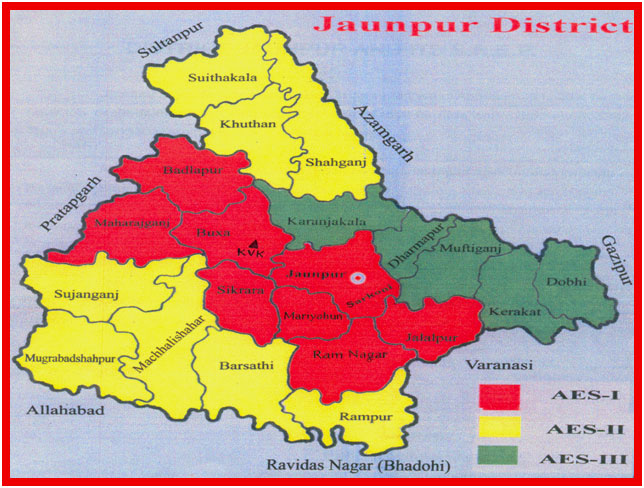
| 2 | AES I | Lomy sand to sandy soil, undulating and eroded topography with tube well irrigation. Major crops sown in the AES are paddy, Maize, Sugarcane, Arhar in kharif and Wheat, Gram, Mustard and zaid Maize, Urd, Moong in rabi season. Under vegetable & fruits major crops are Potato, Okra, Chilies, vegetable pea, tomato, Mango, Guava, Jackfruit, Banana, Karaunda. Major livestock in this area are local cows, cross Jersey, Murrah and goats as Jamunapari, Barbari, Jaunpuri. Prominent farming system in this areas are crop production, crop production - Horticulture – Animal Husbandry and Crop Production-Horticulture-Animal Husbandry-Fisheries farming. |
| 3 | AES II | Soil type of this AES areas are silt loam & clay loam Topography of soil is plain and irrigation facilities are canal & state tube well. Major crop of this area under kharif are Paddy, Maize, Sugarcane, Arhar. In rabi, Wheat, Gram, Mustard and in Zaid Maize Urd & Moong. Major vegetable & fruit crops in these areas are Potato, Brinjal, Okra, Chilli, Onion, Mango, Guava & Aonla. Major livestock of that area are local cow, cross Jersey, Murrah and goats as Jaunpuri and Dominant farming systems of the area are Crop Production, Crop Production-Horticulture, Crop Production-Horticulture & Crop Production-Horticulture-Animal Husbandry-Fisheries. |
| 4 | AES III | Soil of this areas is sandy loam to loam. topography of the soil is plain and irrigation facilities are canal & state tubewell. Major crop of this AES are also in kharif Paddy, Maize, Sugarcane and in rabi wheat, Gram, Pea & Mustard and in Zaid Maize, Urd & Moong. Major horticultural crops viz., Vegetable & fruit in these areas are Potato, Onion, Vegetable Pea, Tomato, Cauliflower, Mango, Guava, Banana citrus, Karaunda. While major livestock are also local cow, cross Jersey, Murrah and goats as Jaunpuri, Barbari & Jamunapari. Major farming system of these area are also Crop Production, Crop Production-Horticulture, Crop Production-Horticulture-Animal Husbandry & Crop Production-Horticulture-Animal Husbandry-Fisheries. |
| S.N. | Soil Type | Characteristics | Area in ha |
|---|---|---|---|
| 1 | Loamy Sand, Sandy Soil | Upland soil, Poor in Soil, fertility, Deep water table undulating and eroded soil | 96,652 |
| 2 | Salty Loam & Clay Loam | Sodic, water logged low land soil, Poor in soil fertility sallow water table, canal are the major irrigation source | 1,64,497 |
| 3 | Loam, Sandy Loam, Alluvial | Mostly Plain Soil, Major area in under irrigation, source of irrigation bore well canal & state tube well | 1,35,846 |